Optimization of inspection days and personnel are now built right into your all-inclusive bridge deck inspection system. The Alynix Corridor Planning Tool, part of the Decker Infrared Drone System, allows DOTs, engineering consultants, and infrastructure managers to streamline how they inspect large networks of bridge decks across corridors, districts, counties, or entire state inventories – without lane closures or placing field crews in harm’s way.
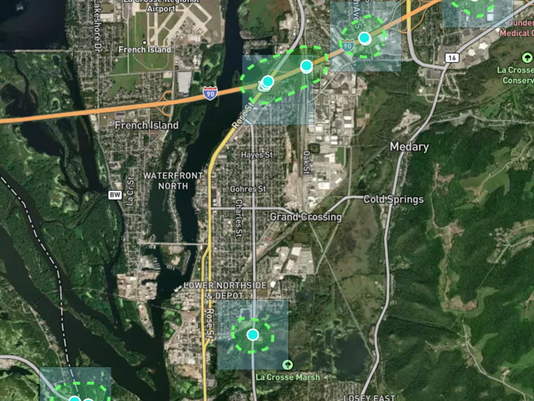
Plan by Polygon: Target Your Inspection Efforts
With the polygon selection feature, you can outline your area of interest whether it’s a specific corridor, an inspection district, or a statewide program with just a few mouse clicks. The Corridor Planning Tool automatically groups bridges that can be scanned in a single day based on location, access, and scanning efficiency. It then visualizes these clusters on a map, helping you understand daily work zones at a glance.
Need to reorganize? No problem. You can split or regroup clusters to reflect your staffing resources, weather limitations, or other logistical factors.
Know Your Timeline and Your Budget
Once your bridge network is grouped, the Corridor Planning Tool estimates how many days it will take to scan all bridge decks in that area with one or more Decker IRT drone systems. More importantly, it calculates the personnel and equipment costs for the entire effort, giving you a clear, data-driven look at your inspection budget before you ever take off.
That means no surprises, better planning, and faster approvals for program-wide inspections.
Triage and Prioritize, All from the Air
Once the Decker drone system completes its thermal scans, you’ll receive a clear condition snapshot of every bridge deck in your selected corridor. With that data, you can:
- Prioritize decks that need rehabilitation or repair
- Schedule in-depth inspections only where necessary
- Identify decks in good condition that don’t require further attention
All of this is done without shutting down lanes and without exposing inspectors to live traffic conditions.
Bottom Line: The Alynix Corridor Planning Tool transforms your Decker drone from just another UAV into a strategic asset for statewide or district-level bridge management. Plus it’s all included in the monthly lease fee for the system. Smarter inspection & planning starts here.
Learn more at Alynix.com